 |
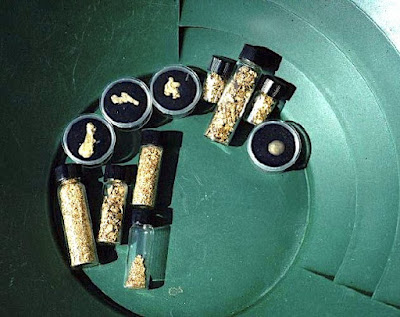
| Overlooked placer gold on Rock Creek. This area had been mined prior to 1941, but this was missed by the mining operations of the Fisher Dredge company in Wyoming. |
Over the years, I discovered many interesting colored gemstone, diamond and gold deposits, so, I have experience in finding the good stuff. How much good stuff? I don't know, but it definitely amounts to $billions in other people's pockets. So, in this and other blogspots, I provide information to lead others to mineral deposits, where they can enjoy the outdoors.
Historically, precious metals and gemstones have been interesting to people for a long time. That flint and chert kept early mankind warm and well fed, and biblical archaeology provides examples of gems and gold before the birth of Christ.
If you learn a few things about mineral deposits, learn where the best place to start searching for your mother lode. Just remember, employ facts and scientific methods unlike the mainstream media. If we learned anything about the plandemic of 2019-, it was facts are important and governments distort and misuse facts (propaganda) and even murder people to promote their agenda. You need to learn to analyze facts and science and ignore mainstream media, big pharmacy, Gates, Fauci and government - they've proven they care nothing for people and science, only greed.
There have been many examples of propaganda over the past few years. So, learn about chemistry, astronomy, physics, biology, zoology, geology, history, geography and archaeology - these disciplines are important for understanding how to see past the pervasive propaganda and lies. We can no longer rely on government or news media, they are compromised by bribes.
How about global warming! Is there or isn't there? Start by asking Al Gore - didn't he tell us all of the earth's glaciers would be long gone 8 to 10 years ago? And remember, many do-dos on FB thought he was a scientist and expert on melting ice. How do you think he paid for a giant, electrical sink of a house in California? And where did all of those $millions come from?
Then there is Obama - where does he live? Just a couple of feet at most, above sea level. Do you really think these people are looking out for us and believe in fast, rising sea levels? I know a PhD in geology, certified member of the democratic party in Wyoming, and Al Gore's cousin. Year's ago, he, was my best friend (until I started pulling knives out of my back from his democrat buddies). He once told me the Gore family made its fortune on milling lead-zinc ore in the Tennessee area, and then leaving behind the largest superfund project in the US for the rest of us. And then he did it to us again with his global warming expertise. Remember, his cousin also told me that Cousin Al, took one basic class on global warming in college. He has no expertise, and yet those morons at the nobel price committee gave him and Obama nobel prizes for a price - not for science or peace. So, no matter what your neighbor next door says (you know, the one who doesn't know what sex, species, or planet she is from), these guys only study money.


Increasing taxes line pockets of politicians and do anything to help our planet (which by the way, has been subjected to climatic change over the past 4.5 billion years, while the entire universe has seen climatic change over the past 13.8 billion years. Yes, we can clean up waste (plastics, politicians, drug companies, Gates, Soros, Biden, etc), but change global warming? How do you turn the heat down on the sun, stop solar storms, correct earth's precession and orbit trajectory, change magnetic poles, etc. Some civilizations, such as a advanced civilization(?) around Tabbys star can do something, but until we see an ad from these little green people, we don't even know if they can or will fix our exit from a natural ice age. And, just think about our ancestors with their receded foreheads - were they even concerned about the melting of Beringia and rise in sea level 16 to 17 thousand years ago? Oops, looks like I'm getting off the subject again - so, let me take a deeeeeep breath, collect my thoughts, and start thinking about gold!
CLASSIFICATION OF GOLD DEPOSITS
There are many geological designations and classifications of gold deposits. For prospectors and government, a simple classification scheme is used: (1) placer gold, (2) lode gold, and (3) leasable gold (Hausel, 2001). Examples of placers include Nome and Flat, Alaska, the Yuba River, California, Alder Gulch, Montana; Douglas Creek, Big Atlantic Gulch and Rock Creek, Wyoming. Famous lodes include the Mother Lode, California and the Homestake, South Dakota. In Wyoming, some lodes include Miners Delight, Carissa and Mary Ellen in the Wind River Mountains. Leasable deposits are those that are available to lease from State government, private mineral estates, reservations, etc, and these include both placers and lodes. One example would be the Copper King gold-copper deposit near Cheyenne that is located on a school section. Even though this would be considered a lode deposit, it is located on State of Wyoming land and cannot be staked and would have to be leased from state government.
 |
| Faulted quartz vein (lode) exposed in bedrock (metatonalite) on the 120-foot level of the Mary Ellen gold mine, South Pass |
Placer Deposits
Placer gold deposits consist of secondary detrital gold that has been transported and reworked by water. This gold could be found in beaches, streams, rivers, alluvial fans, etc. Some placers form as a result of wave action along a beach at the edge of a lake, sea, or ocean, such as the great diamond deposits along the west coast of Africa, or the famous gold deposits of Nome, Alaska.
Gold placers can be wet or dry. If the placer formed in an active stream from a distal source terrain, cobbles and boulders associated with the gold will be rounded and stream worn, as would much of the gold. If the placer is eluvial or proximal, it will contain more angular cobbles and boulders and the deposit could sit high and dry away from any running water. The gold in these placers could be angular as well.
 |
Julian Creek, Alaska nuggets. The large nugget (> 1 ounce)
is stream worn and rounded suggestive of a distal source
but the remaining nuggets provide conflicting evidence.
These have features suggestive of a more
proximal source for some of the gold. |
The gold content of placers will vary along the length of the stream and at depth and it is important to learn about paystreaks in placers. Paystreaks are zones in gravel that are enriched in gold content. These may form during flash flooding events and some placers will have more than one paystreak preserved in layers of coarse gravel at depth or further down the stream. When prospecting placer deposits, a good prospector will also look for additional valuable minerals, such as rubies, sapphires, diamonds, etc., and should always keep in mind that somewhere upstream, the gold originated from a lode deposit. Was it a proximal source, a distal source, or was there more than one source upstream?
In addition to gold, diamonds were found at the Cortez Creek placer in Wyoming by late prospector Paul Boden. At the Poker Flat placer in California, I found gem-quality sapphire and benitoite with gold.
While working in Alaska, our company (WestGold) examined placers at Donlin Creek in the Kuskokwim Mountains because the gold morphology suggested a proximal source. Some gold was angular (like corn flakes) and some nuggets looked so fragile as if they could have been precipitated from water in place. It was apparent that much of this gold originated from the immediate area. This resulted in a multi-million ounce lode gold discovery up stream. But at another placer known as Julian Creek, the stream yielded considerable gold, but some of the gold was rounded suggested of a distal source. We did not spend much time looking for the source of that gold, but somewhere along that drainage is an excellent source (or sources) for placer gold, particularly since much of the gold was coarse and many rounded nuggets weighing more than one ounce were found by prospectors.
Placers always have heavy minerals known as black sands. These are dark opaque minerals with greater than average specific gravity that can include magnetite, ilmenite, garnet, sphene, chromite and monazite. Panning along the banks of most active streams will result in recovery of black sand concentrates. If you are an accomplished gold panner; you should be able to remove all light-colored material from your pan in a very short time. Sometimes this process can be sped up using a combination grizzly pan with a gold pan particularly where one encounters considerable coarse material with fine grained material.
 |
A fragile nugget from Snow Gulch, Donlin Creek, Alaska.
The nugget projects off a rounded rhyolite pebble.
The pebble is steam worn, but the nugget is pristine &
suggestive of gold that precipitated from the water.
Some placers will regenerate over time due to this
phenomenon whereby organics & organic acids appear to
mobilize gold in water & precipitate the metal so that
nuggets will actually grow in place.
|
A rule of thumb for differentiating gold from mica is that gold will NOT reflect light like a mirror and it will NOT roll or flip over and over in the water while panning. Gold it way too heavy and will sit on the bottom of the pan. When a prospector finally sees gold in a pan, mica is usually no longer mistaken for the precious metal. Other minerals of interest with relatively high specific gravity that periodically show up in a gold pan include cassiterite (tin oxide), garnet, scheelite (calcium tungstate), ruby, sapphire, sphene and diamond, as well as metals with specific gravities close to that gold such as mercury, platinum and palladium.
 |
Jay Roberts pans for heavy minerals in the Laramie Range.
In this exercise, he used a grizzly pan (a pan with 0.25 inch
holes drilled in the bottom) & sieved the material onto the gold
pan. At this point, he quickly discarded the coarse material
looking to be sure there are no nuggets or large diamonds. Next
he quickly panned all of the material in the gold pan. Gold
being heavy should stay in the bottom of the pan.
|
While working for Western Archon & searching for diamonds in California, we recovered benitoite and sapphire in a placer at Poker Flat in the Sierra Nevada upstream from the gold and diamond placers in Sacramento. While prospecting for diamonds in the Laramie Mountains, panned samples contained trace ruby and sapphire (Hausel and others, 1988; Hausel, 1998b) thought to have been released from nearby mica schist and gneiss during erosion. These provide evidence for undiscovered gem deposits. Two prospectors from Rock Springs also found a few hundred pieces of corundum (including one of 90 carats) in a placer near the Big Sandy River at the southern tip of the Wind River Mountains. The corundum was poor quality, but the source area remains undiscovered. Ruby schist with transparent ruby and pink sapphire was purportedly found a few miles upslope from this area (Ron Frost, personal communication, 2005), but the source of the schist remains unverified and questionable as are similar reports of diamonds in Tourist Creek in the Wind River Mountains.
In streams, heavy minerals (dark and light colored) are intermixed with light colored minerals with low specific gravity. This mix tends to migrate downstream due to gravity and is accelerated with rainfall and flash-flooding. Nearly all placer gold paystreaks in deserts are associated with flash flooding events and many occur in fanglomerates with angular cobbles and boulders. Thus better paystreaks (with few exceptions) are almost always associated with coarse gravel on bedrock, or can be several feet above bedrock.
The carrying capacities of streams will diminish with decreasing water velocity. Greater amounts of heavy minerals concentrate where stream velocities decrease. The heavy minerals concentrate at the bottom and along the leading edge of stream meanders, behind obstructions (i.e., rocks, cracks in bedrock) and at waterfalls. Since many streams lack sufficient velocity to carry gold for any great distance, the vast majority of gold (particularly where concentrated in pay streaks) is transported during flash floods or heavy spring runoff. Flash flooding is very important in transporting gold down slope. When searching for placer gold, one should always look for layers of coarse gravel and remember that there usually has been more than one past flash flood. Flash flooding events may be recognized by coarse layers of mixed gravel (possibly with tree limbs, etc), in a stream bed that is separated by layers of fine-grained gravel, sand and clay. The sand and clay would have been transported and deposited in the past during times when the water velocity was relatively low, as compared to cobbles and boulders that would have required considerable water energy to move.
 |
| Always a good sign of gold! Rainbow at the Duncan mine, South Pass, Wyoming. |
Some minerals can transport greater distances. Diamond is an extreme example. Diamond is 6000 to 8000 times harder than any other mineral except lonsdaleite (which is 30 to 58% harder than diamond and much rarer) and carbonado, but diamond has moderate specific gravity of 3.52 compared to 2.87 for quartz. There are examples in Africa where diamond appears to have transported more than 600 miles in rivers (Erlich and Hausel, 2000). Such great transportation distances for gold are not possible.
Where meanders form in streams, if gold is present, it will concentrate on the inside of the initial curve in the meander (where water velocity and carrying capacity of the stream declines significantly). Keep in mind that dry stream banks adjacent to a wet pay streak were also deposited by the same stream in the past, thus if you find gold in the active stream, you will find gold in the bank adjacent to the stream, such as in the bank gravels next to the Bobbie Thompson campground in the historical Douglas Creek gold district in the Medicine Bow Mountains.
 |
Consolidated Tertiary conglomerate from the
Seminoe Mountains. Even though both are fossil placers, most would be considered as lodes by the 1872 Mining Law since they are hard, brittle, rock found in place. |
Paleoplacers are common in Wyoming due to considerable erosion in the past. Some of these paleoplacers are gigantic and appear to have considerable gold resources and remain mostly unexplored at best. The Wyoming paleoplacers include ancient, consolidated, brittle, Proterozoic (~2 billion years old) paleoplacers in the Medicine Bow and Sierra Madre Mountains that are the unexplored equivalents of the Witwatersand deposits. These Wyoming deposits have produced several uranium, thorium, gold and diamond anomalies.
The Medicine Bow and Sierra Madre paleoplacers have yielded scattered gold anomalies and a few diamonds. These are uranium-thorium enriched deposits. One Proterozoic paleoplacer exposed in the Ferris-Haggarty mine in the Sierra Madre forms a rare copper-gold-silver deposit and may be one of the only copper paleoplacers in the world, although others would argue that this deposit is mill rock (volcanoclastic). Based on mapping by Graff (1979) and field observations, this deposit appears to be a paleoplacer with rounded pebbles and cobbles but the presence of copper in a paleoplacers is difficult to support. More research is necessary to determine its origin and it could easily represent a mill rock formed by a submarine black smoker nearly 2 billion years ago.
Other paleoplacers include poorly consolidated to unconsolidated Tertiary age (~50 to 20 million years old) paleoplacers at South Pass, Seminoe Mountains and other localities in Wyoming. Those at South Pass likely have zones with commercial amounts of gold based on their source terrain. For the most part, the Mining Law would classify these younger paleoplacers as placers. Such large paleoplacers suggest that the gold and lithic fragments were derived from a nearby source terrain.
Gold deposits south of South Pass in the Dickie Springs-Oregon Gulch area have pebbles, cobbles and boulders that are for the most part angular and suggestive of a nearby to eluvial source terrain. In places, these paleoplacers have been modified and reworked by narrow and restricted intermittent streams which have upgraded the gold content. Thus higher gold contents are usually found in gravels with rounded pebbles and cobbles in this area. Gold in much of this paleoplacer is often angular suggestive of a proximal or eluvial source.
Gold from eluvial deposits will show little or no evidence of transport. Some of these may be classified as fanglomerates – basically conglomerates within alluvial fans. Most such conglomerates will have angular cobbles and boulders that suggest little wear and tear from water transportation, although portions of fanglomerates and eluvial deposits should show reworking and rounding of pebbles locally. Gold in fanglomerates is usually angular, just like the pebbles and boulders. The gold in reworked deposits typically will have rounded pebbles and the gold itself will be rounded.
 |
| Fanglomerate near Dickie Springs has gold interspersed within sandy & silty matrix surrounding cobbles & pebbles.The rocks are characteristic of a proximal source suggesting that most, if not all of the gold, was derived from South Pass greenstone belt now buried under nearby Tertiary cover. Thus this fanglomerate likely had an eluvial to proximal gold source. Also note at the base of this prospect pit, cobbles are comparatively coarse & angular suggestive of flash flooding. The Dickie Springs- Oregon Gulch paleoplacer was estimated to have 28.5 million ounces of gold according to the USGS! |
Eluvial deposits are essentially detrital material weathered in place from an underlying source rock. These are particularly abundant in arid regions of Arizona and New Mexico and most likely sit on or adjacent to lodes. An example is the Greaterville placers in Arizona. These consist of mixed eluvial and alluvial material with rhyolite and granite lithic fragments that are angular. A few nuggets recovered from the deposit were described to have attached galena. According to the 1872 mining law, the Greaterville placers would likely be classified as placers, but because of close and intricate association with veins, many such deposits likely sit on top of a hidden lode. Eluvial deposits are small but some may overlie a high-grade lode and probably should be staked with both placer and lode claims.
If you spend much time looking for gold, you are likely to come across other valuable minerals, such as platinum, palladium, ruby, sapphire, gem garnet, diamond, scheelite and others. Look in your black sands for these as they will stay in a gold pan with your gold flakes and nuggets.
Many diamonds have been found in gold placers and it is likely that thousands were thrown away by prospectors not realizing that they had something of incredible value.
 |
| Stretched pebble conglomerate, Medicine Bow Mountains, Wyoming |
 |
| Dry placer (fanglomerate) at the Vulture mine, Arizona. This deposit is a consolidated conglomerate that geologists would classify as a dry placer due to abundant rounded stream worn pebbles. Even though it is Tertiary in age, it is consolidated enough to drive an adit into the conglomerate. |
 |
Gold from the Dickie Springs-Oregon Gulch
paleoplacers. Note that coarse flakes (0.25
inch across), have rough, angular edges,
similar to corn flakes. This morphology
indicates the gold was likely eluvial & the
source to be within a few feet to a few
hundred yards rather than many miles as
suggested by past researchers.
|